Fleetwood seafront and beach extends from Rossall Beach at Cleveleys all the way to the estuary of the River Wyre. You can walk all the way along it from Cleveleys to Fleetwood.
It follows the land peninsula into the estuary of the River Wyre, at the bottom end of Morecambe Bay. Explore the outer promenade – the footpath right along the edge of the beach. Or walk the inner promenade – the footpaths and spaces along the edge of the highway, hugging the coast line in some places but not others.

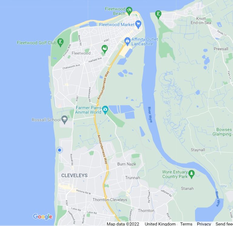
Fleetwood seafront has three different looks.
- There’s the quiet, peaceful parts around the Rossall coastal defence scheme which opens up into dune systems, natural beaches and grasslands.
- Then the traditional seaside with ‘man-made’ features near The Mount at The Esplanade and Marine Beach. That’s the boating lakes and ponds, gardens, pitch and putt, lighthouses and seafront shops.
- As the coast turns into the Wyre estuary, there’s the industrial area of the docks and finally, beyond the docks is the natural landscape of Fleetwood Marsh Nature Park.
Many of the original Victorian features and architecture still exist. There are many heritage buildings like The Mount Pavilion and Fleetwood Museum.
- Travel Around Fleetwood Seafront
- Drive and Walk along Fleetwood Seafront
- Rossall Coastal Defence Scheme
- Fleetwood Golf Course and Rossall Point
- Rossall Tower
- Boating Lakes
- Marine Hall Seafront and Beach
- The Mount
- Ferry Beach and The Esplanade
- Dock Street – where Fleetwood Seafront joins the River Wyre
- Fleetwood Marsh Nature Park
- While you’re here…
Travel Around Fleetwood Seafront
In this page, we leave Cleveleys in the south at Rossall School and carry on travelling north around the coastline with the beach and sea on your left.
Drive and Walk along Fleetwood Seafront
The shingle of Rossall Beach at Cleveleys gives way to old, tired seawalls near the tank traps in front of Rossall School. The seafront highway also ends at Rossall Beach, to divert slightly inland against the Fleetwood to Blackpool tramway.
Follow the seafront on foot…
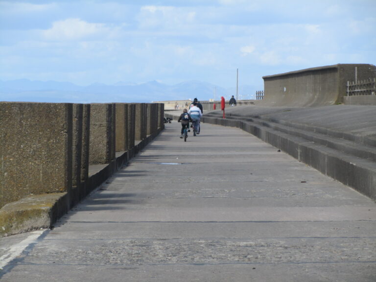
If you carry on walking along the seafront footpath from Cleveleys, you’ll go through the five bar gate at the very end of Rossall Promenade. This marks the end of the seafront highway. This section of seawall is old, much-repaired concrete with new rock groynes. The rock groynes are part of the Wyre Beach Management Project, to create high stable beaches.
FREE Newsletter
FREE Newsletter

Watch the water!
Not far along the footpath, as you approach the concrete blocks, you’ll see a water outlet set into the sea wall. This is a land drain which discharges surface water from the nearby fields onto the beach.
If you hear a gurgling noise, get out of the way because this is what happens next:

Enjoyed this video? Why don’t you subscribe to the Visit Fylde Coast YouTube channel, for loads more great content!
On your right you’ll clearly see the back of Rossall School – a private school, set in its own grounds. Literally at the side of the land drain, a series of tall concrete pillars raise out of the sea wall.
These pillars (below left) are known locally as the ‘tank traps’. Evidence points to them having being built in WW2 to stop invading troops approaching from the beach.
There was once an open air swimming pool in the field at Rossall School. The tall wall at the right of shot was built to protect it.
Drive or follow the main road…
You can’t drive past Rossall School against the sea – the highway bends inland here – between Thornton Gate (Cleveleys) and Westway (Fleetwood).
The next clip was filmed in 2015 while the sea defence works were still in progress, so we need to get the dashcam rigged up and take new footage. Still an interesting look at the seafront though – and how it looked before the recent works were completed.
It covers the drive from Rossall Hospital at Westway, to the Sea Cadets base at the end of Beach Road.
Rossall Hospital (now a care home) is on your right. Behind it on the corner of Westway, are new houses, built where the original Rossall Hospital once stood.

Rossall Coastal Defence Scheme
2km of new sea defences (just over a mile) occupy the seafront between Westway and Fleetwood Golf Course. It protects 7,500 properties from the risk of flooding. The Rossall Coastal Defence Scheme is a £63m project, completed in 2018.
It’s a huge piece of civil engineering – about twice as wide as the one it replaced. It rises out of the beach, built in three distinct sections. First, a rock revetment takes the majority of the abrasion from the sea, then a stepped sea defence offers a second line of protection.

The wide promenade itself is split into two levels, with finally the rear flood wall and Larkholme Grasslands beyond. The amazing public space is very wide, so not easy to photograph!

The grassy overflow land to the rear (Larkholme Grasslands) has been relandscaped into an ecology park.
The overflow channel is still in place to collect any overtopping (particularly in later years) but now takes the form of a meandering stream. As a Biological Heritage Site, the Larkholme Grasslands is an environment adapted to the harsh conditions, and home to a wide variety of wildlife.

Fleetwood Golf Course and Rossall Point
The Rossall Coastal Defence Scheme ends where Fleetwood Golf Course begins. Rossall Point is just what it sounds like, the place where the coast starts to turn eastwards at the tip of the peninsula. Rossall Tower is at the right hand edge of the golf course.
As the land starts to turn away from the prevailing weather, it means there’s no need for a big concrete sea defence. Instead, the sand and shingle beach provides the best kind of natural sea defences that there is. In 2024, rock armour toe protection and groynes were built to improve these natural defences. It’s a wild and lovely place, perfect for walking.

A small, natural dune system backs the seafront footpath. The dune has grown over the years, created by grasses trapping the windblown sand.
The beaches here are wide, open and wonderful to enjoy if you like peace and quiet, walking and seaside pastimes like fishing, horse riding and kite flying. Enjoy five minutes of peaceful sea sounds –

Enjoyed this video? Why don’t you subscribe to the Visit Fylde Coast YouTube channel, for loads more great content!
Rossall Tower
Designed to lean into the wind, Rossall Tower is a public building with a number of uses.

- The ground floor is an information point and somewhere to shelter when the weather turns. Pop in and have a look at leaflets and beach finds.
- The National Coastwatch Institute monitor the sands at our end of Morecambe Bay from the first floor.
- The top floor is an open observation deck. It’s well worth a climb to the top to take in the amazing view.
To the north of Rossall Tower are public car parks, a children’s play area and the Log Cabin. There’s also a large open field where you can enjoy a picnic or a game of football. It’s a popular spot and well used throughout the year for all manner of things, from walking the dog to large outdoor family parties at the weekend. Take a look in this next video from 2015 –

Enjoyed this video? Why don’t you subscribe to the Visit Fylde Coast YouTube channel, for loads more great content!
Boating Lakes
Once you head north beyond the open green spaces of the golf course links you come to the boating lakes. The model boat club use the square left hand one for their meetings, events and competitions.

The other, larger one is used for canoeing and training. Blackpool and the Fylde College also use this larger boating lake for their nautical college students.

The boating lakes are home to swans and geese who have trained the public to come and feed them! The swans allow the model boat enthusiasts to use the smaller pond for their sport and competitions.
This amazing aerial photo of Fleetwood seafront and the boating lakes was taken from a plane by Visit Fylde Coast contributor Juliette Gregson (September 2014) –

Marine Hall Seafront and Beach
Fleetwood seafront from the boating lakes to the docks retains its Victorian heritage and is really attractive, traditional British seaside. Beyond the boating lakes is a pitch and putt and rolling green grassy gardens. Walk the footpath along the length of the beach towards the seaside of the green open space, or use the promenade where you can sit and take in the view from one of the seafront shelters.
Next stop on your journey is the Marine Hall itself. Indoors, it’s a multi-use function space while outside it’s surrounded by attractive gardens, beach huts and bowling greens. Next to the Marine Hall are the indoor sports facilities, with the swimming pool and sports hall, and plenty of free parking.

Seaside Beach
To the rear of the Marine Hall you’ll find the accessible, open, sandy Marine Beach. There are also facilities here like public toilets and cafes to make your day out on the beach more comfortable.

It’s also where you’ll find the beach huts. There are two different styles, the traditional pastel coloured ones (below) and others of a modern design, integrated into the colonnades of Marine Hall.

Beach Wheelchairs
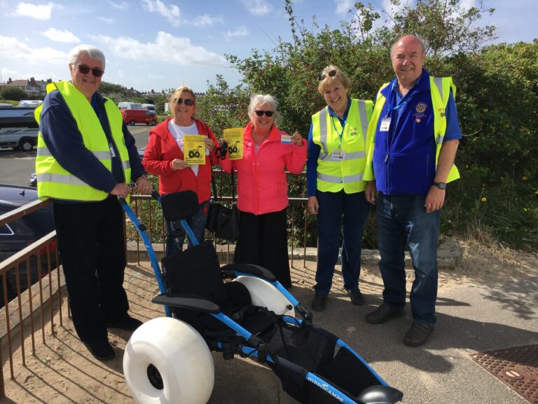
Very few places in the UK can claim to have truly accessible beaches for wheelchair users, but Fleetwood can.
Registered charity Fleetwood Beach Wheelchairs has worked hard to make this facility a reality. With the help of Healthier Fleetwood and Fleetwood Rotary, people with disabilities can now access the sands.
The Mount
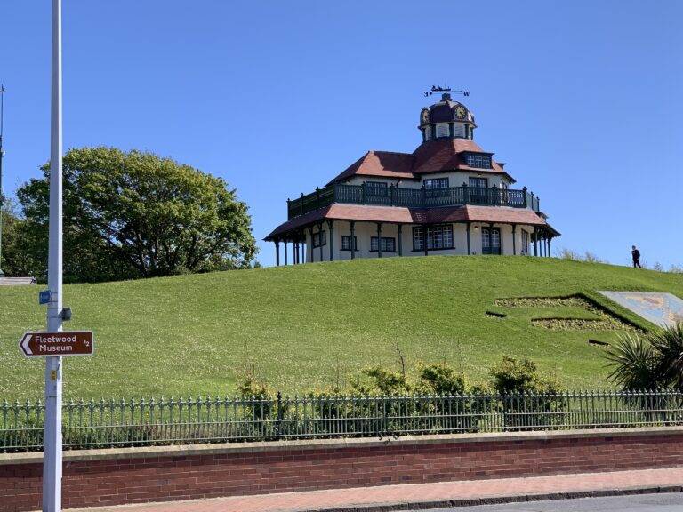
Opposite the Marine Hall is The Mount, with the Mount Pavilion at the top of The Mount itself, with public grounds open to enjoy. Towards the rear (with protection from the prevailing wind) are park areas and a children’s playground.
The gardens have recently been renovated with new features and planting to restore the original Victorian features of this well loved local landmark.
Ferry Beach and The Esplanade
Next on the seafront at The Esplanade you’ll reach Ferry Beach, adjacent to Fleetwood RNLI lifeboat station.
There’s free parking here, right next to the promenade, so you can sit in your car facing over the water. Two of Fleetwood’s three lighthouses are here. Can you spot the third one, out at sea?
Look across the channel of the River Wyre to Knott End with Morecambe Bay, Heysham and the Lakes beyond. It’s a fabulous view, you’ll see for miles on a clear day.
It’s also a site of Special Scientific Interest where you’ll see plants and native sea holly growing, they’re specially adapted to the harsh, salty sea air. In turn, the plants attract a wide variety of wildlife and birds.

This is the old Victorian quarter of Fleetwood, with lots of old, architecturally important buildings. There’s the RNLI shop and boathouse, the Fleetwood to Knott End Ferry, and the shops and amusements at the seafront – all making up a traditional seaside scene.
Behind you is the North Euston Hotel and Euston Gardens.
Dock Street – where Fleetwood Seafront joins the River Wyre
Our last video clip from 2015 covers the journey from Fleetwood Museum to Eros roundabout on Amounderness Way.

This is Dock Street. On the left is the disused land which was once the container parking for the ferry to Ireland. Eventually the brownfield site will be redeveloped.
You’ll also pass Fleetwood Museum on your right, it was originally the old Customs House.

A mixture of building styles
There’s an eclectic mix of buildings along Dock Street. Fleetwood Railway Station was here, which is why Fleetwood grew in the first place. You can still see the splendour of some of these old buildings. Thankfully a number of them are still standing – some are beautifully restored. Spaces show where others have been demolished – making way for modern buildings.
Unmistakable and next on your right is the Asda supermarket.
A little further along, beyond the next big roundabout and next to the Marina, is the shopping outlet Affinity Lancashire. You can see its green roofs in the next aerial photo, also taken by Juliette Gregson in 2014 –

Pick up the main A585 bypass road at Affinity Lancashire and follow the quick, straight route out of Fleetwood.
The next big roundabout you come to is Eros Roundabout. Turn left and quickly left again at Eros roundabout for the vehicular entrance to Fleetwood Marsh Nature Park.
Fleetwood Marsh Nature Park
Fleetwood Marsh Nature Park is against the banks of the River Wyre and accessed via Jamieson Road. See the small oval car park between two ponds in the centre of the next photo. See beautiful views and green landscapes as a reward for your efforts!
Fleetwood Marsh is against the tidal banks of the River Wyre and is a rich habitat for an amazing variety of wildlife. It’s a great open space for walking and enjoyment of the outdoors. Abandoned boats lie against the edge of the river making a good subject for artists and photographers.
Here’s another of Juliette Gregson’s aerial photos from 2014. In it you can see the footpaths at the Nature Park, extending along the river bank behind the new housing estate to Affinity Lancashire. There’s now a footbridge across the harbour entrance.

While you’re here…
Go to the homepage of the Visit Fleetwood website for the latest updates.
Love the Fylde Coast? Sign up for your email newsletter. Packed full of interesting things it arrives in your inbox all 52 weeks of the year.
Join us on Facebook at our Visit Fylde Coast Facebook Group and follow us on Twitter @visitFyldeCoast
Plus hundreds of videos to watch on our YouTube channel – from all over the Fylde Coast!
Booking a stay? Pick a safe, clean and legal place to stay, at the very best price. Book with the Visit Fylde Coast and StayBlackpool guide.

We Need Your Help
We Need Your Help